


Uncover the electrifying secrets of thunderstorms, their causes, dangers, and the myths surrounding them.

-
En español
-
Pay bill
Please verify your service location to access this:
-
Contact us
Please verify your service location to access this:
-
Electricity & gas

Choose Direct Energy
Direct Energy is dedicated to helping you choose the right energy solutions for your unique needs. Find the perfect fit with our electricity and natural gas plans today.
-
Home solutions

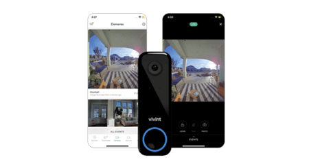

A smarter, safer home
Home security, automation and efficiency at your fingertips. Protect your peace of mind with an exclusive offer from our partner Vivint.
-
Learning center


25 energy-efficient tips for lower electricity costs
Discover practical, energy-saving tips to reduce electricity costs and increase efficiency at home or business. Knowledge is power, literally!
-
Support


Download the app
Get the Direct Energy app to easily pay your bill, manage your account, keep an eye on your usage, refer friends and more.

Choose Direct Energy
Direct Energy is dedicated to helping you choose the right energy solutions for your unique needs. Find the perfect fit with our electricity and natural gas plans today.
A smarter, safer home
Home security, automation and efficiency at your fingertips. Protect your peace of mind with an exclusive offer from our partner Vivint.
25 energy-efficient tips for lower electricity costs
Discover practical, energy-saving tips to reduce electricity costs and increase efficiency at home or business. Knowledge is power, literally!
Download the app
Get the Direct Energy app to easily pay your bill, manage your account, keep an eye on your usage, refer friends and more.